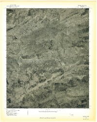
1977 Map of Higgins
USGS Topo · Published 1977About this map
Blue Mountain dominates the central landscape of this 1977 orthophoto, a transitional document produced by the U.S. Geological Survey in cooperation with the Soil Conservation Service. The settlement of Higgins sits at the base of the ridge, providing a look at rural Oklahoma's structural footprint in the late 1970s. The aerial imagery captures the meandering paths of Gaines Creek and Buffalo Creek as they cut through the terrain. Unlike traditional topographic maps, this orthophotograph uses rectified imagery to reveal the literal texture of the land, showing the exact boundaries of fields, timber stands, and dirt tracks that standard line-and-symbol maps might generalize.
Find a feature on this map
4 named features on this map. Tap any name to fly to it.
Don’t see what you’re looking for? This feature index may not catch every label — zoom into the map to look around manually.
Map Details
Editions of this 1977 Higgins Map
This is the sole edition of this map. No revisions or reprints were ever made.
Other maps of this area

1898 · McAlester
USGS Topo · 1:125,000

1901 · Tuskahoma
USGS Topo · 1:125,000

1908 · Tuskahoma
USGS Topo · 1:125,000

1909 · Mc Alester
USGS Topo · 1:125,000

1909 · Tuskahoma
USGS Topo · 1:125,000

1950 · Mcalester
USGS Topo · 1:250,000

1962 · McAlester
USGS Topo · 1:250,000

1965 · McAlester
USGS Topo · 1:250,000
1967 · Adamson
USGS Topo · 1:24,000

1967 · Hartshorne
USGS Topo · 1:24,000