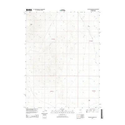
2014 Map of High Bald Peaks NE
USGS Topo · Published 2014About this map
The Medicine Range dominates the western half of this Nevada landscape, where high ridgelines overlook the broad expanse of Butte Valley. The terrain drops sharply toward the northeast corner of the quadrangle into The Narrows, a distinct topographical pinch point where drainage flows through the mountain chain. Water is scarce in this high desert environment, with Butte Cr serving as the primary hydrologic feature as it moves through the valley floor. Transportation is limited to a single mapped artery, CR-784, which follows the base of the mountains. This 2014 survey records a largely unpopulated stretch of Elko County, structured by the Public Land Survey System grids of t27n r61e and t27n r62e, illustrating the vast open grazing and range lands characteristic of the Great Basin.
Find a feature on this map
9 named features on this map. Tap any name to fly to it.
Don’t see what you’re looking for? This feature index may not catch every label — zoom into the map to look around manually.
Map Details
Editions of this 2014 High Bald Peaks NE Map
This is the sole edition of this map. No revisions or reprints were ever made.
Other maps of this area

1955 · Elko
USGS Topo · 1:250,000

1958 · Elko
USGS Topo · 1:250,000

1962 · Elko
USGS Topo · 1:250,000

1965 · Elko
USGS Topo · 1:250,000
1984 · Paris Creek
USGS Topo · 1:24,000
1984 · Mt. Taylor
USGS Topo · 1:24,000
1984 · High Bald Peaks SE
USGS Topo · 1:24,000
1984 · Silo Canyon
USGS Topo · 1:24,000
1984 · High Bald Peaks
USGS Topo · 1:24,000
1984 · Medicine Spring
USGS Topo · 1:24,000