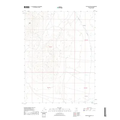
2018 Map of High Bald Peaks NE
USGS Topo · Published 2018About this map
The Medicine Range dominates the western portion of this 2018 survey, characterized by significant elevation changes that transition into the wide expanse of Butte Valley to the east. This high-desert landscape in Elko County reveals a remote network of drainage systems, including the seasonal flow of Little Tomhicken Cr and the more prominent Butte Cr, which meanders through the northeast. A notable geographical constriction occurs at The Narrows, where the valley floor tightens before opening back up toward the south. Historically significant for its open-range characteristics, the area is accessible primarily via Butte Valley Rd, which tracks the eastern foothills. The map provides a detailed look at the cadastral grid across multiple townships, including t27n r61e, which highlights how public land surveys organized this expansive Great Basin terrain for grazing and resource management.
Find a feature on this map
10 named features on this map. Tap any name to fly to it.
Don’t see what you’re looking for? This feature index may not catch every label — zoom into the map to look around manually.
Map Details
Editions of this 2018 High Bald Peaks NE Map
This is the sole edition of this map. No revisions or reprints were ever made.
Other maps of this area

1955 · Elko
USGS Topo · 1:250,000

1958 · Elko
USGS Topo · 1:250,000

1962 · Elko
USGS Topo · 1:250,000

1965 · Elko
USGS Topo · 1:250,000
1984 · Paris Creek
USGS Topo · 1:24,000
1984 · Mt. Taylor
USGS Topo · 1:24,000
1984 · High Bald Peaks SE
USGS Topo · 1:24,000
1984 · Silo Canyon
USGS Topo · 1:24,000
1984 · High Bald Peaks
USGS Topo · 1:24,000
1984 · Medicine Spring
USGS Topo · 1:24,000