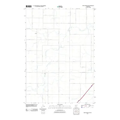
2010 Map of High Forest SW
USGS Topo · Published 2010About this map
Evanger Cemetery and Zion Cemetery stand as quiet landmarks within this rural expanse of Mower County, marking the long-standing heritage of the local community. The landscape is defined by the winding course of the North Branch Root River, which meanders through a grid of agricultural section lines and county roads. This 2010 survey illustrates the organized land use of the region, where the river's natural hydrology contrasts with the precise geometry of thoroughfares like Dodge-Mower Rd and County Hwy-7. In the southern reaches, Robinson Creek and North Fork Bear Creek contribute to the drainage system, supporting the fertile farmstead environment that has sustained the area for generations.
Find a feature on this map
34 named features on this map. Tap any name to fly to it.
Don’t see what you’re looking for? This feature index may not catch every label — zoom into the map to look around manually.
Map Details
Editions of this 2010 High Forest SW Map
This is the sole edition of this map. No revisions or reprints were ever made.
Other maps of this area

1954 · Austin
USGS Topo · 1:62,500

1954 · Mason City
USGS Topo · 1:250,000

1955 · High Forest
USGS Topo · 1:62,500

1957 · Mason City
USGS Topo · 1:250,000

1958 · Mason City
USGS Topo · 1:250,000

1965 · Dexter
USGS Topo · 1:24,000

1965 · Grand Meadow
USGS Topo · 1:24,000
1966 · Hayfield
USGS Topo · 1:24,000

1966 · Sargeant
USGS Topo · 1:24,000
1974 · Rock Dell
USGS Topo · 1:24,000