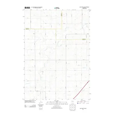
2013 Map of High Forest SW
USGS Topo · Published 2013About this map
Evanger Cem and Zion Cem sit within the rural agricultural landscape at the convergence of Dodge, Olmsted, and Mower counties. This 2013 survey illustrates the dense section-line road network that organizes the region, with Co Hwy-7 and Co Hwy-149 Sw serving as primary north-south corridors. The drainage patterns of the N Br Root River and its tributaries, including Robinson Cr and N Fork Bear Cr, provide the primary relief in an otherwise strictly partitioned terrain of farmsteads and fields. The map documents the enduring rural infrastructure of south-central Minnesota, where local routes like 750th St and 250th Ave maintain the historic grid established during the original land surveys.
Find a feature on this map
39 named features on this map. Tap any name to fly to it.
Don’t see what you’re looking for? This feature index may not catch every label — zoom into the map to look around manually.
Map Details
Editions of this 2013 High Forest SW Map
This is the sole edition of this map. No revisions or reprints were ever made.
Other maps of this area

1954 · Austin
USGS Topo · 1:62,500

1954 · Mason City
USGS Topo · 1:250,000

1955 · High Forest
USGS Topo · 1:62,500

1957 · Mason City
USGS Topo · 1:250,000

1958 · Mason City
USGS Topo · 1:250,000

1965 · Dexter
USGS Topo · 1:24,000

1965 · Grand Meadow
USGS Topo · 1:24,000
1966 · Hayfield
USGS Topo · 1:24,000

1966 · Sargeant
USGS Topo · 1:24,000
1974 · Rock Dell
USGS Topo · 1:24,000