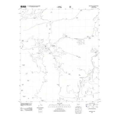
2011 Map of High Rolls
USGS Topo · Published 2011About this map
High Rolls and Mountain Park form the residential heart of this canyon-dissected landscape in the Sacramento Mountains. The 2011 survey reveals a complex network of forest roads and trails, such as Bootlegger Rd and Skyline Trl, winding through the drainage systems of Fresnal Creek and La Luz Creek. This era of the region is defined by its transition from historic resource extraction to recreation and mountain living, evidenced by the proximity of the Warnock Mine and Courtney Mine to modern landmarks like the YMCA Skyline Ranch and Tunnel Vista. Local geography is intricately detailed with named canyons like Mexican Canyon and Wooten Canyon, while higher elevations are marked by Calico Peak and Ortega Peak. The map serves as a precise record of late-twentieth-century residential expansion along narrow ridges, where development follows the contours of the terrain near the Karr Canyon Picnic Area and numerous campgrounds.
Find a feature on this map
65 named features on this map. Tap any name to fly to it.
Don’t see what you’re looking for? This feature index may not catch every label — zoom into the map to look around manually.
Map Details
Editions of this 2011 High Rolls Map
This is the sole edition of this map. No revisions or reprints were ever made.
Other maps of this area

1950 · Alamogordo
USGS Topo · 1:62,500

1950 · Mescalero
USGS Topo · 1:62,500

1952 · Cloudcroft
USGS Topo · 1:62,500

1954 · Carlsbad
USGS Topo · 1:250,000

1955 · Roswell
USGS Topo · 1:250,000

1958 · Carlsbad
USGS Topo · 1:250,000

1958 · Roswell
USGS Topo · 1:250,000

1962 · Roswell
USGS Topo · 1:250,000

1963 · Firman Canyon
USGS Topo · 1:24,000
1974 · Bluff Springs
USGS Topo · 1:24,000