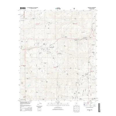
2013 Map of High Rolls
USGS Topo · Published 2013About this map
Lincoln National Forest dominates this landscape in the Sacramento Mountains, where the communities of High Rolls, Mountain Park, and Cloudcroft follow the corridor of US Hwy 82. The terrain is characterized by a complex network of deep drainages, including Fresnal Canyon and Haynes Canyon, which define the local topography. This 2013 survey illustrates how settlement and infrastructure remain tied to these high-altitude passes and valleys.
Find a feature on this map
56 named features on this map. Tap any name to fly to it.
Don’t see what you’re looking for? This feature index may not catch every label — zoom into the map to look around manually.
Map Details
Editions of this 2013 High Rolls Map
This is the sole edition of this map. No revisions or reprints were ever made.
Other maps of this area

1950 · Alamogordo
USGS Topo · 1:62,500

1950 · Mescalero
USGS Topo · 1:62,500

1952 · Cloudcroft
USGS Topo · 1:62,500

1954 · Carlsbad
USGS Topo · 1:250,000

1955 · Roswell
USGS Topo · 1:250,000

1958 · Carlsbad
USGS Topo · 1:250,000

1958 · Roswell
USGS Topo · 1:250,000

1962 · Roswell
USGS Topo · 1:250,000

1963 · Firman Canyon
USGS Topo · 1:24,000
1974 · Bluff Springs
USGS Topo · 1:24,000