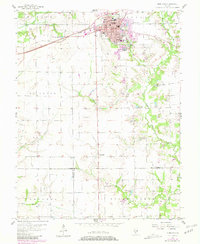
1957 Map of Highland
USGS Topo · Published 1981About this map
Highland serves as the focal point of this Madison County landscape, where the Conrail rail line and major thoroughfares like Lindenthal Ave and Broadway converge. The town's social fabric is visible through institutions like the High Sch and St Paul Sch, along with the central Lindenthal Park. To the south, the small settlement of St Morgan marks the rural expanse, while the surrounding townships of Saline, St. Jacob, and Helvetia are defined by an agricultural grid dotted with several family and community burial grounds, including Rietmann Cem and Hoyt Cem.
Find a feature on this map
36 named features on this map. Tap any name to fly to it.
Don’t see what you’re looking for? This feature index may not catch every label — zoom into the map to look around manually.
Map Details
Editions of this 1957 Highland Map
3 editions found
Other maps of this area

1906 · Breese
USGS Topo · 1:62,500

1907 · Breese
USGS Topo · 1:62,500

1907 · Belleville
USGS Topo · 1:62,500

1927 · Edwardsville
USGS Topo · 1:62,500

1932 · Edwardsville
USGS Topo · 1:62,500

1935 · Lebanon
USGS Topo · 1:24,000

1937 · New Douglas
USGS Topo · 1:48,000

1944 · New Douglas
USGS Topo · 1:62,500

1949 · Lebanon
USGS Topo · 1:24,000

1949 · St. Jacob
USGS Topo · 1:24,000