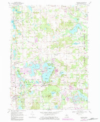
1968 Map of Highland
USGS Topo · Published 1984About this map
Glacial lakes and suburban growth define this Oakland County landscape, where the Chesapeake and Ohio railroad corridor links the established communities of Clyde and Highland. The 1968 topography, updated with later revisions, reveals a transition from traditional lakefront retreats to more permanent residential patterns, particularly around the complex shorelines of White Lake and Duck Lake. This era shows the development of leisure-focused infrastructure, including the Alpine Ski Club and the sprawling Highland State Recreation Area. Local institutions like the Duck Lake Sch and Emmanuel Ch serve the burgeoning neighborhoods of Seven Harbors and East Highland. The map preserves the footprint of earlier rural life through landmarks like the Rose Center Cem and the small settlement at Rose Center, while indicating the modern shift toward outdoor recreation and residential expansion near Haven Hill Lake.
Find a feature on this map
87 named features on this map. Tap any name to fly to it.
Don’t see what you’re looking for? This feature index may not catch every label — zoom into the map to look around manually.
Map Details
Editions of this 1968 Highland Map
4 editions found
Other maps of this area

1907 · Pontiac
USGS Topo · 1:62,500

1909 · Milford
USGS Topo · 1:62,500

1920 · Holly
USGS Topo · 1:62,500

1922 · Holly
USGS Topo · 1:62,500

1936 · Wixom
USGS Topo · 1:31,680

1936 · Highland
USGS Topo · 1:31,680

1936 · Clarkston
USGS Topo · 1:31,680

1936 · Walled Lake
USGS Topo · 1:31,680

1942 · Highland
USGS Topo · 1:24,000

1943 · Holly
USGS Topo · 1:62,500
Featured Places
- White Lake Charter Township, MI
- Highland Charter Township, MI
- Springfield Charter Township, MI
- Rose Township, MI
- Seven Harbors, Highland Charter Township