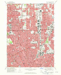
1968 Map of Highland Park
USGS Topo · Published 1971About this map
Detroit's dense urban footprint and its enclave cities define this late 1960s landscape, illustrating a period of intense post-war development and industrial connectivity. The map captures the tight residential grids of Highland Park and Hamtramck, surrounded by the city's expanding northern limits. Transport corridors like the Chrysler Freeway and Edsel Ford Freeway cut through the established neighborhoods, while the Grand Trunk Western RR and Detroit Terminal RR underscore the area's historic reliance on rail for commerce.
Find a feature on this map
54 named features on this map. Tap any name to fly to it.
Don’t see what you’re looking for? This feature index may not catch every label — zoom into the map to look around manually.
Map Details
Editions of this 1968 Highland Park Map
4 editions found
Other maps of this area

1905 · Detroit
USGS Topo · 1:62,500

1905 · Grosse Pointe
USGS Topo · 1:62,500

1908 · Rochester
USGS Topo · 1:62,500

1912 · Mt Clemens
USGS Topo · 1:62,500

1918 · Detroit
USGS Topo · 1:62,500

1918 · Grosse Pointe
USGS Topo · 1:62,500

1924 · Detroit
USGS Topo · 1:62,500

1929 · Mt Clemens
USGS Topo · 1:62,500

1934 · Detroit
USGS Topo · 1:62,500

1936 · Warren
USGS Topo · 1:31,680