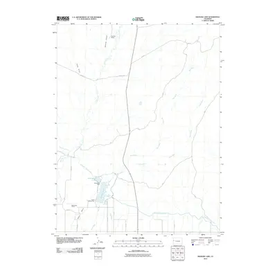
2010 Map of Highline Lake
USGS Topo · Published 2010About this map
Mack Mesa Lake and Highline Lake anchor this 2010 survey of the high desert terrain north of the Colorado River valley. The landscape is defined by the critical water management systems of the American West, most notably the Government Highline Canal which contours through the southern portion of the quadrangle. This infrastructure, along with the Mack Mesa Dam and Upper Highline Dam, illustrates the engineering efforts required to sustain agriculture and local aviation at the Mack Mesa Airport in an otherwise arid environment.
Find a feature on this map
30 named features on this map. Tap any name to fly to it.
Don’t see what you’re looking for? This feature index may not catch every label — zoom into the map to look around manually.
Map Details
Editions of this 2010 Highline Lake Map
This is the sole edition of this map. No revisions or reprints were ever made.
Other maps of this area

1956 · Grand Junction
USGS Topo · 1:250,000

1959 · Grand Junction
USGS Topo · 1:250,000

1960 · Grand Junction
USGS Topo · 1:250,000

1962 · Grand Junction
USGS Topo · 1:250,000

1962 · Fruita
USGS Topo · 1:24,000

1962 · Mack
USGS Topo · 1:24,000

1964 · Grand Junction
USGS Topo · 1:250,000

1965 · Grand Junction
USGS Topo · 1:250,000

1968 · Badger Wash
USGS Topo · 1:24,000
1968 · Carbonera
USGS Topo · 1:24,000