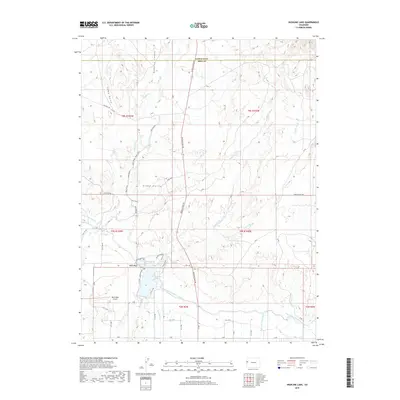
2019 Map of Highline Lake
USGS Topo · Published 2019About this map
Highline Lake and the engineering of the Government Highline Canal dominate this landscape within the Grand Valley. The map details a sophisticated network of irrigation and water management essential to this arid region, where drainages like Peck and Beede Wash and Coyote Wash cut through the terrain. The area around Mack Mesa serves as a hub for local infrastructure, featuring the Mack Mesa Airport and a grid of numbered rural roads such as 13 Rd and Q Rd. Recreational footprints are visible through the Highline Lake Trail, Greasewood Flats Trail, and Eagle Loop. To the north, the terrain becomes increasingly dissected by deep cuts like Demaree Canyon and Comp Gulch, illustrating the transition from the irrigated valley floor to the high desert plateaus of the Garfield Co and Mesa Co border.
Find a feature on this map
50 named features on this map. Tap any name to fly to it.
Don’t see what you’re looking for? This feature index may not catch every label — zoom into the map to look around manually.
Map Details
Editions of this 2019 Highline Lake Map
This is the sole edition of this map. No revisions or reprints were ever made.
Other maps of this area

1956 · Grand Junction
USGS Topo · 1:250,000

1959 · Grand Junction
USGS Topo · 1:250,000

1960 · Grand Junction
USGS Topo · 1:250,000
1962 · Grand Junction
USGS Topo · 1:250,000
1962 · Fruita
USGS Topo · 1:24,000
1962 · Mack
USGS Topo · 1:24,000
1964 · Grand Junction
USGS Topo · 1:250,000
1965 · Grand Junction
USGS Topo · 1:250,000
1968 · Badger Wash
USGS Topo · 1:24,000
1968 · Carbonera
USGS Topo · 1:24,000