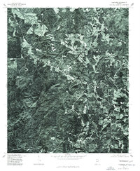
1975 Map of Hightower
USGS Topo · Published 1977About this map
Lecta and Hightower appear as centers of rural activity in this mid-1970s orthophotoquad of eastern Cleburne County. Unlike a traditional line-drawn map, this photographic record reveals the specific texture of the Alabama landscape as it existed in November 1975, showing the clear boundaries between forested ridges and the agricultural clearings surrounding Union Hill. The meandering path of the Tallapoosa River cuts across the northwest corner of the sheet, providing a vital water source and geographic boundary for the region. Produced in cooperation with the Soil Conservation Service, the imagery allows for a detailed study of land use and timber management in a period of rural stability. This map is particularly useful for researchers tracing the physical evolution of small crossroads communities and family farmsteads that defined the county's character during the late twentieth century.
Find a feature on this map
4 named features on this map. Tap any name to fly to it.
Don’t see what you’re looking for? This feature index may not catch every label — zoom into the map to look around manually.
Map Details
Editions of this 1975 Hightower Map
This is the sole edition of this map. No revisions or reprints were ever made.
Other maps of this area

1889 · Tallapoosa
USGS Topo · 1:125,000

1891 · Ashland
USGS Topo · 1:125,000

1892 · Tallapoosa
USGS Topo · 1:125,000

1897 · Tallapoosa
USGS Topo · 1:125,000

1899 · Wedowee
USGS Topo · 1:125,000

1900 · Anniston
USGS Topo · 1:125,000

1902 · Wedowee
USGS Topo · 1:125,000

1953 · Atlanta
USGS Topo · 1:250,000

1957 · Atlanta
USGS Topo · 1:250,000

1958 · Atlanta
USGS Topo · 1:250,000