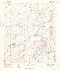
1968 Map of Hildreth
USGS Topo · Published 1971About this map
The Santa Fe River and Ichetucknee River converge in this late-1960s landscape, marking the intersection of Suwannee, Columbia, and Gilchrist counties. This survey highlights the region's unique hydrologic features, most notably the crystal-clear Ichetucknee Springs and the nearby Blue Hole. These natural springs flow south through a low-lying terrain punctuated by numerous sinks and ponds, including Sampson Lake and Clear Pond, which define the local drainage patterns before reaching the river forks.
Find a feature on this map
33 named features on this map. Tap any name to fly to it.
Don’t see what you’re looking for? This feature index may not catch every label — zoom into the map to look around manually.
Map Details
Editions of this 1968 Hildreth Map
4 editions found
Other maps of this area

1954 · Gainesville
USGS Topo · 1:250,000

1954 · Valdosta
USGS Topo · 1:250,000

1958 · Valdosta
USGS Topo · 1:250,000

1958 · Gainesville
USGS Topo · 1:250,000

1959 · Valdosta
USGS Topo · 1:250,000

1959 · Gainesville
USGS Topo · 1:250,000

1963 · Columbia
USGS Topo · 1:24,000

1968 · Branford
USGS Topo · 1:24,000

1968 · Hatchbend
USGS Topo · 1:24,000
1968 · Hildreth
USGS Topo · 1:24,000