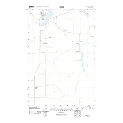
2010 Map of Hill City
USGS Topo · Published 2010About this map
Hill City anchors the northern landscape of this quadrangle, situated where the Hill River flows south from Hill Lake. The town's grid is detailed alongside the Hill City Post Office, while the surrounding terrain is defined by the elevation of Quadna Mountain and the presence of the Hill City-Quadna Mountain Airport. This 2010 survey illustrates a complex hydrological system characterized by managed water flow, including the Moose-Willow Number 1 Dam and Moose-Willow Number 2 Dam along the Moose River Flowage. To the south, the settlement of Haypoint sits near the Macville Cemetery, marking a distinct node of habitation. Large portions of the eastern and southern sectors are dominated by the Savanna State Frst, where the Moose River Pool and the meandering Willow River create a vast wetland environment, reflecting the region's managed timber and water resources.
Find a feature on this map
40 named features on this map. Tap any name to fly to it.
Don’t see what you’re looking for? This feature index may not catch every label — zoom into the map to look around manually.
Map Details
Editions of this 2010 Hill City Map
This is the sole edition of this map. No revisions or reprints were ever made.
Other maps of this area

1953 · Duluth
USGS Topo · 1:250,000

1954 · Hibbing
USGS Topo · 1:250,000

1957 · Hibbing
USGS Topo · 1:250,000

1958 · Hibbing
USGS Topo · 1:250,000

1958 · Duluth
USGS Topo · 1:250,000

1964 · Hibbing
USGS Topo · 1:250,000

1970 · Split Hand Lake
USGS Topo · 1:24,000

1970 · Rabey
USGS Topo · 1:24,000

1970 · Big Thunder Peak
USGS Topo · 1:24,000
1970 · Mountain Ash Lake
USGS Topo · 1:24,000