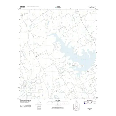
2010 Map of Hill City
USGS Topo · Published 2010About this map
The Squaw Creek Reservoir dominates the eastern half of this landscape, its indented shoreline creating a complex system of coves and branches such as Million Branch and Contrary Creek. Created to support local infrastructure, the reservoir is contained by the Squaw Creek Dam and includes the specialized Safe Shutdown Impoundment Dam. To the west, the settlement of Hill City sits at the junction of Harkins Ct and Hill City Hwy, while the Paluxy River winds through the southern reaches near Cedar Brake.
Find a feature on this map
51 named features on this map. Tap any name to fly to it.
Don’t see what you’re looking for? This feature index may not catch every label — zoom into the map to look around manually.
Map Details
Editions of this 2010 Hill City Map
This is the sole edition of this map. No revisions or reprints were ever made.
Other maps of this area

1889 · Granbury
USGS Topo · 1:125,000

1923 · Granbury 2-a
USGS Topo · 1:48,000

1923 · Granbury 1-b
USGS Topo · 1:48,000

1924 · Granbury 1-c
USGS Topo · 1:48,000

1928 · Godley
USGS Topo · 1:62,500

1931 · Morgan
USGS Topo · 1:62,500

1931 · Tolar
USGS Topo · 1:62,500

1954 · Dallas
USGS Topo · 1:250,000

1958 · Dallas
USGS Topo · 1:250,000
1960 · Tolar
USGS Topo · 1:24,000