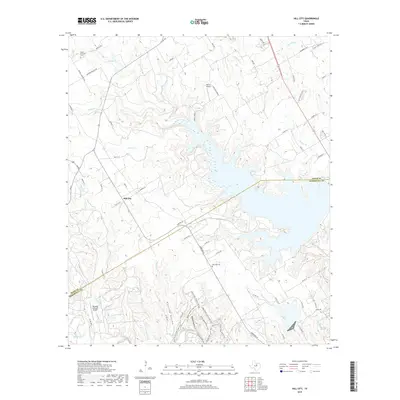
2019 Map of Hill City
USGS Topo · Published 2019About this map
The settlement of Hill City sits near the heart of this North Texas landscape, where the meandering drainage of Squaw Cr meets a sprawling reservoir system at the Hood Co Somervell Co line. This modern 2019 survey documents a terrain defined by deep hollows and intermittent streams, with Opossum Hollow and Wildcat Hollow cutting through the limestone-heavy geography south of the lake. The rural character of the region is preserved in its scattered historic burial grounds, including Mount Pleasant Cem in the northwest and Post Oak Cem further south.
Find a feature on this map
69 named features on this map. Tap any name to fly to it.
Don’t see what you’re looking for? This feature index may not catch every label — zoom into the map to look around manually.
Map Details
Editions of this 2019 Hill City Map
This is the sole edition of this map. No revisions or reprints were ever made.
Other maps of this area

1889 · Granbury
USGS Topo · 1:125,000

1923 · Granbury 2-a
USGS Topo · 1:48,000

1923 · Granbury 1-b
USGS Topo · 1:48,000

1924 · Granbury 1-c
USGS Topo · 1:48,000

1928 · Godley
USGS Topo · 1:62,500

1931 · Morgan
USGS Topo · 1:62,500

1931 · Tolar
USGS Topo · 1:62,500

1954 · Dallas
USGS Topo · 1:250,000

1958 · Dallas
USGS Topo · 1:250,000
1960 · Tolar
USGS Topo · 1:24,000