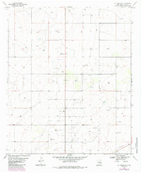
1970 Map of Hillburn City
USGS Topo · Published 1985About this map
Hillburn City serves as the focal point of this Lea County landscape, illustrating a specialized settlement pattern shaped by the region's energy resources. The map highlights the extensive footprint of the Caudill Oil Field, where a network of pipelines and infrastructure like the Pumping Sta define the local economy and land use during the 1970s and early 1980s.
Find a feature on this map
10 named features on this map. Tap any name to fly to it.
Don’t see what you’re looking for? This feature index may not catch every label — zoom into the map to look around manually.
Map Details
Editions of this 1970 Hillburn City Map
Other maps of this area

1954 · Hobbs
USGS Topo · 1:250,000

1954 · Brownfield
USGS Topo · 1:250,000

1958 · Brownfield
USGS Topo · 1:250,000

1958 · Hobbs
USGS Topo · 1:250,000

1962 · Brownfield
USGS Topo · 1:250,000

1962 · Lovington
USGS Topo · 1:24,000

1962 · Lovington
USGS Topo · 1:62,500

1970 · Prairieview
USGS Topo · 1:24,000

1970 · Prairieview NW
USGS Topo · 1:24,000

1970 · Hillburn City
USGS Topo · 1:24,000