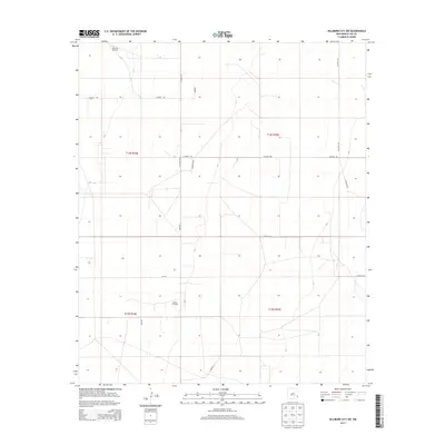
2013 Map of Hillburn City SW
USGS Topo · Published 2013About this map
The Morton Oil Field anchors the southern portion of this Lea County landscape, reflecting the long-standing energy infrastructure of the Permian Basin. This 2013 survey illustrates a rectilinear grid of section lines and county roads, such as Co Road 108 and Watson Rd, that partition the arid high plains. The terrain is sparsely populated, defined primarily by its industrial and agricultural utility rather than urban centers. Small-scale water infrastructure like the West Jim Windmill in the northwest corner speaks to the traditional ranching heritage that persists alongside oil extraction. Local landmarks such as Hilburn and Hightop provide geographic orientation within the sprawling townships of t14s r34e and t15s r35e. The map also captures several named tracks including Martine Ln and Alma Ln, which serve the remote operations scattered across this high-desert plateau.
Find a feature on this map
20 named features on this map. Tap any name to fly to it.
Don’t see what you’re looking for? This feature index may not catch every label — zoom into the map to look around manually.
Map Details
Editions of this 2013 Hillburn City SW Map
This is the sole edition of this map. No revisions or reprints were ever made.
Other maps of this area

1954 · Hobbs
USGS Topo · 1:250,000

1954 · Brownfield
USGS Topo · 1:250,000

1958 · Brownfield
USGS Topo · 1:250,000

1958 · Hobbs
USGS Topo · 1:250,000

1962 · Brownfield
USGS Topo · 1:250,000
1962 · Lovington
USGS Topo · 1:24,000
1962 · Lovington
USGS Topo · 1:62,500
1962 · Buckeye
USGS Topo · 1:62,500
1970 · Hillburn City
USGS Topo · 1:24,000
1970 · Tatum South
USGS Topo · 1:24,000