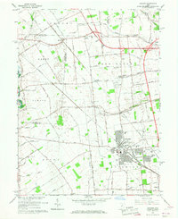
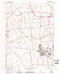
1966 Map of Hilliard
USGS Topo · Published 1968About this map
Hilliard serves as the primary hub of this central Ohio landscape, positioned where the industrial influence of the Pennsylvania and New York Central railroads intersects with a largely agricultural interior. Small hamlets and named crossroads such as Kileville, Hayden, Lamb Corners, and the curiously named Mudsock dot the region, marking the early nodes of settlement before modern expansion. This map provides a detailed view of the rural-to-suburban transition during the mid-1960s, showing the early layout of the County Fairground and Hamilton Park alongside established community pillars like the Marblestone Ch and Avery Sch. The terrain is defined by the winding course of Big Darby Creek and its tributaries, which established the natural boundaries for the surrounding townships of Jerome, Washington, and Canaan. Local genealogists will find significant value in the documentation of numerous family-named roads and burial sites, including the St Johns Ch Cem.
Find a feature on this map
67 named features on this map. Tap any name to fly to it.
Don’t see what you’re looking for? This feature index may not catch every label — zoom into the map to look around manually.
Map Details
Editions of this 1966 Hilliard Map
5 editions found
Other maps of this area

1901 · Dublin
USGS Topo · 1:62,500

1903 · Dublin
USGS Topo · 1:62,500

1907 · London
USGS Topo · 1:62,500

1916 · Milford Center
USGS Topo · 1:62,500

1923 · West Columbus
USGS Topo · 1:62,500

1925 · West Columbus
USGS Topo · 1:62,500

1944 · Milford Center
USGS Topo · 1:62,500

1947 · Columbus
USGS Topo · 1:250,000

1950 · Marion
USGS Topo · 1:250,000
1954 · Shawnee Hills
USGS Topo · 1:24,000