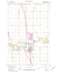
1963 Map of Hillsboro
USGS Topo · Published 1984About this map
The Goose River meanders sharply across this Red River Valley landscape, defining the geographic heart of the region near Hillsboro. This 1963 survey, photorevised in the early 1980s, documents a transition in infrastructure and land use, showing the Burlington Northern railroad corridor and the development of Sew Disp Ponds near the river's edge. The settlement of Taft and the various rural townships including Norway and Eldorado reveal a well-ordered agricultural grid typical of North Dakota's eastern plains.
Find a feature on this map
21 named features on this map. Tap any name to fly to it.
Don’t see what you’re looking for? This feature index may not catch every label — zoom into the map to look around manually.
Map Details
Editions of this 1963 Hillsboro Map
3 editions found
Other maps of this area

1918 · Kelso
USGS Topo · 1:62,500

1918 · Hendrum
USGS Topo · 1:62,500

1919 · Eldred
USGS Topo · 1:62,500

1943 · Kelso
USGS Topo · 1:62,500

1952 · Grand Forks
USGS Topo · 1:250,000

1956 · Grand Forks
USGS Topo · 1:250,000

1963 · Hillsboro
USGS Topo · 1:24,000

1963 · Kelso
USGS Topo · 1:24,000

1963 · Halstad SW
USGS Topo · 1:24,000

1964 · Climax SW
USGS Topo · 1:24,000