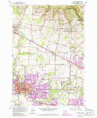
1961 Map of Hillsboro
USGS Topo · Published 1986About this map
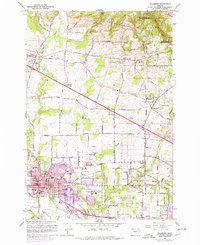
Hillsboro serves as the central hub for this mid-century portrait of Washington County, Oregon, revealing a landscape defined by the intersection of rail infrastructure and valley agriculture. The map documents the extensive rail networks of the Burlington Northern, Southern Pacific, and Oregon Electric RR which shaped the early development of outlying settlements like Orenco, Sewell, and Witch Hazel. A significant historical landmark, the Historical Marker Joseph L Meek Land Claim, anchors the northern reaches, while the transition toward modern infrastructure is evident in the Hillsboro Airport and the expanding residential footprints. This survey captures a moment of balance between rural heritage, seen in the many scattered cemeteries like Tualatin Plains Cem, and the encroaching urban growth from the east near Beaverton.
Find a feature on this map
64 named features on this map. Tap any name to fly to it.
Don’t see what you’re looking for? This feature index may not catch every label — zoom into the map to look around manually.
Map Details
Editions of this 1961 Hillsboro Map
5 editions found
Other maps of this area

1915 · Hillsboro
USGS Topo · 1:62,500

1916 · Tualatin
USGS Topo · 1:62,500

1918 · Hillsboro
USGS Topo · 1:62,500

1939 · Tualatin
USGS Topo · 1:62,500

1940 · Tualatin
USGS Topo · 1:62,500

1940 · Hillsboro
USGS Topo · 1:62,500

1941 · Gales Creek
USGS Topo · 1:62,500

1941 · Yamhill
USGS Topo · 1:62,500

1942 · Yamhill
USGS Topo · 1:62,500

1948 · Vancouver
USGS Topo · 1:250,000