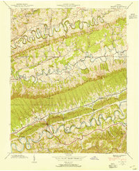
1938 Map of Hilton
USGS Topo · Published 1954About this map
Dorton Fort stands as a sentinel over the tight, meandering loops of Copper Creek in this pre-war study of Scott County. The landscape is defined by the sharp, parallel ridges of Moccasin Ridge and Clinch Mountain, which forced early settlement into narrow valleys. Along the North Fork Holston River, the Southern railway line mirrors the water's path, connecting small communities like Maces Spring and Hilton. The presence of multiple milling sites, including McConnell Mill and Holston River Mill, suggests a local economy still deeply tied to water power and agriculture. Numerous family-named churches and schools, such as Sayler Chapel and Mt Hagan Sch, populate the hollows, providing a rich dataset for genealogists tracing Appalachian families before mid-century modernization altered the rural social fabric.
Find a feature on this map
69 named features on this map. Tap any name to fly to it.
Don’t see what you’re looking for? This feature index may not catch every label — zoom into the map to look around manually.
Map Details
Editions of this 1938 Hilton Map
4 editions found
Other maps of this area

1894 · Estillville
USGS Topo · 1:125,000

1897 · Bristol
USGS Topo · 1:125,000

1902 · Bristol
USGS Topo · 1:125,000

1920 · Wise
USGS Topo · 1:48,000

1920 · Coeburn
USGS Topo · 1:48,000

1921 · Wise
USGS Topo · 1:62,500

1935 · Hilton
USGS Topo · 1:24,000

1935 · Moggasin
USGS Topo · 1:48,000

1935 · Mendota
USGS Topo · 1:24,000

1935 · Blountville
USGS Topo · 1:24,000