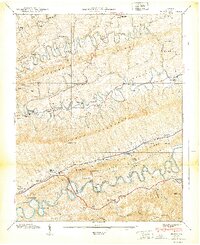
1939 Map of Hilton
USGS Topo · Published 1939About this map
Moccasin Ridge and Clinch Mountain dominate this corner of Scott County, where the landscape is defined by the sharp meanders of Moccasin Creek and the North Fork Holston River. This 1930s era topography shows a rural economy built around the river and rail, anchored by the Southern Railway passing through Hilton and Maces Spring. The presence of Dorton Fort and numerous family-named landmarks like Francisco Cem and Sayler Chapel provides deep material for genealogical research. Local industry is visible at the Holston River Mill and McConnell Mill, while the social fabric is marked by a high density of country schools and chapels, including Cedar Point Sch and New Bethel Ch. The map captures the region's complex geography of gaps and ridges, from Hamilton Gap to Little Pine Ridge.
Find a feature on this map
71 named features on this map. Tap any name to fly to it.
Don’t see what you’re looking for? This feature index may not catch every label — zoom into the map to look around manually.
Map Details
Editions of this 1939 Hilton Map
2 editions found
Other maps of this area

1894 · Estillville
USGS Topo · 1:125,000

1897 · Bristol
USGS Topo · 1:125,000

1902 · Bristol
USGS Topo · 1:125,000

1920 · Wise
USGS Topo · 1:48,000

1920 · Coeburn
USGS Topo · 1:48,000

1921 · Wise
USGS Topo · 1:62,500

1935 · Hilton
USGS Topo · 1:24,000

1935 · Moggasin
USGS Topo · 1:48,000

1935 · Mendota
USGS Topo · 1:24,000

1935 · Blountville
USGS Topo · 1:24,000