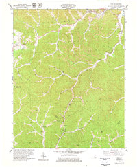
1979 Map of Hima
USGS Topo · Published 1979About this map
Extensive strip mining and coal tipples define the landscape across this region of the Cumberland Plateau, following the winding path of the Louisville and Nashville railroad. The waterway network is dominated by Collins Fork and its numerous tributaries, including Engine Branch and Buzzard Creek. Settlements like Hima and Woollum are centered around the resource extraction industry of the era, with prominent infrastructure such as the Pigeonroost Mine and various strip operations cut into the terrain. For genealogists and local historians, the map provides precise locations for family landmarks and community centers, including Cottongim Cem, the Harris Cem, and rural congregations like Lilly Grove Ch and Antioch Ch. The topographical detail captures a specific moment in the late 1970s when the industrial footprint of coal mining was deeply integrated with the traditional mountain settlements and small post offices of Clay and Knox counties.
Find a feature on this map
59 named features on this map. Tap any name to fly to it.
Don’t see what you’re looking for? This feature index may not catch every label — zoom into the map to look around manually.
Map Details
Editions of this 1979 Hima Map
This is the sole edition of this map. No revisions or reprints were ever made.
Other maps of this area

1886 · Cumberland Gap
USGS Topo · 1:125,000

1888 · Cumberland Gap
USGS Topo · 1:125,000

1891 · Manchester
USGS Topo · 1:125,000

1891 · Cumberland Gap
USGS Topo · 1:125,000

1903 · Pineville
USGS Topo · 1:48,000

1952 · Portersburg
USGS Topo · 1:24,000

1952 · Heidrick
USGS Topo · 1:24,000

1952 · Hima
USGS Topo · 1:24,000

1952 · Blackwater
USGS Topo · 1:24,000

1952 · Fount
USGS Topo · 1:24,000