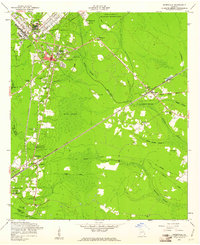
1958 Map of Hinesville
USGS Topo · Published 1961About this map
The Fort Stewart military reservation dominates the northern landscape of this survey, directly bordering the growing community of Hinesville. The town's mid-century expansion is centered around the Bradwell Institute High School, with the Atlantic Coast Line railroad cutting a diagonal path through the wetlands and forests to the southeast. The map reveals a high density of rural religious and community life, marked by numerous country churches such as Taylor Creek Ch, Williams Chapel, and Wilderness Ch, many of which sit alongside family and community burial grounds like Cypress Slash Cem and Bacon Cem. Significant portions of the terrain are identified as named wetlands, including Davis Swamp and Goshen Swamp, where an Artesian Well provides a reliable water source. The presence of an Old Railroad Grade near Allenhurst indicates a shifting industrial landscape as older timber or agricultural lines gave way to modern transit routes.
Find a feature on this map
43 named features on this map. Tap any name to fly to it.
Don’t see what you’re looking for? This feature index may not catch every label — zoom into the map to look around manually.
Map Details
Editions of this 1958 Hinesville Map
3 editions found
Other maps of this area

1918 · Hinesville
USGS Topo · 1:62,500

1920 · Sapelo River
USGS Topo · 1:62,500

1920 · Limerick
USGS Topo · 1:62,500

1943 · Ludowici
USGS Topo · 1:62,500

1943 · Sapelo River
USGS Topo · 1:62,500

1944 · Hinesville
USGS Topo · 1:62,500

1944 · Limerick
USGS Topo · 1:62,500

1945 · Sapelo River
USGS Topo · 1:62,500

1946 · Brunswick
USGS Topo · 1:250,000

1948 · Brunswick
USGS Topo · 1:250,000