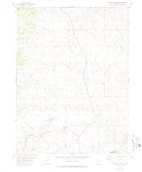
1980 Map of Hinman Reservoir
USGS Topo · Published 1980About this map
Muddy Creek defines the drainage of this high-elevation Grand County landscape, where the seasonal flow and irrigation needs of the late 1970s are evident in features like the Mc Mahon Ditch. The presence of the Hinman Reservoir and various Drill Holes suggests a terrain utilized for both water management and resource exploration. Settlement indicators are sparse but specific, including a lone Cem and multiple Gravel Pits that suggest local infrastructure maintenance. To the south, the topography rises toward Wolford Mountain, with numerous tributaries such as Pass Creek, Red Dirt Creek, and Antelope Creek carving through the valleys. The map provides a detailed record of the water-reliant economy of the era, from the Alkali Slough to the many named springs and gulches that supported ranching or mining activities.
Find a feature on this map
19 named features on this map. Tap any name to fly to it.
Don’t see what you’re looking for? This feature index may not catch every label — zoom into the map to look around manually.
Map Details
Editions of this 1980 Hinman Reservoir Map
2 editions found
Other maps of this area

1954 · Craig
USGS Topo · 1:250,000

1956 · Lake Agnes
USGS Topo · 1:24,000

1956 · Kremmling
USGS Topo · 1:62,500

1956 · Whiteley Peak
USGS Topo · 1:24,000

1956 · Hyannis Peak
USGS Topo · 1:24,000

1956 · Gore Pass
USGS Topo · 1:62,500

1956 · Hyannis Peak
USGS Topo · 1:62,500

1956 · Rabbit Ears Peak
USGS Topo · 1:62,500

1957 · Craig
USGS Topo · 1:250,000

1958 · Craig
USGS Topo · 1:250,000