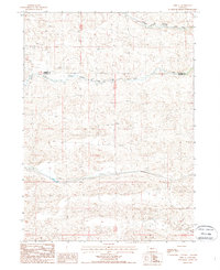
1987 Map of Hire SE
USGS Topo · Published 1988About this map
Middle Branch Middle Loup River and the South Branch Middle Loup River converge in this high-plains landscape along the border of Cherry Co and Hooker Co. The terrain is characterized by the expansive sand hills typical of the Nebraska interior, where elevation is meticulously recorded by markers such as BM 3433.4. This provisional survey preserves the geography of the Sandhills before modern agricultural or infrastructure changes, showing a sparse network of 4wd trails that cross the undulating landscape between the river branches. The absence of permanent settlements or towns highlights the cattle-ranching character of the region during the late twentieth century, focusing instead on the hydrological patterns and natural topography that define land use in this part of the state.
Find a feature on this map
9 named features on this map. Tap any name to fly to it.
Don’t see what you’re looking for? This feature index may not catch every label — zoom into the map to look around manually.
Map Details
Editions of this 1987 Hire SE Map
This is the sole edition of this map. No revisions or reprints were ever made.
Other maps of this area

1947 · Dismal River Ranch
USGS Topo · 1:62,500

1948 · Carr Lake
USGS Topo · 1:62,500

1948 · Mullen
USGS Topo · 1:62,500

1949 · Dismal River Ranch
USGS Topo · 1:62,500

1950 · Carr Lake
USGS Topo · 1:62,500

1950 · Hire
USGS Topo · 1:62,500

1951 · Mullen
USGS Topo · 1:62,500

1954 · North Platte
USGS Topo · 1:250,000

1956 · North Platte
USGS Topo · 1:250,000

1957 · North Platte
USGS Topo · 1:250,000