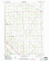
1961 Map of Hoagland
USGS Topo · Published 1994About this map
Hoagland stands as a focal point in this agricultural landscape south of Fort Wayne, where the early 1960s rural layout reflects generations of drainage and development. The terrain is crisscrossed by an extensive network of managed waterways like Flauch Drain, Bohnke Ditch, and Ohler Ditch, which were essential for reclaiming the fertile soil for farming. Near the St Marys River in the southwest, smaller settlements and crossroads such as Boston Corner and Bingin appear alongside established community centers. Educational and religious roots are particularly visible through the presence of institutions like Consolidated Sch, St Johns Sch, and Marquardt Ch. The map also preserves the locations of several historic burial grounds, including Massillon Cem and Brown Cem, providing a detailed record of the area's early family history and township development.
Find a feature on this map
45 named features on this map. Tap any name to fly to it.
Don’t see what you’re looking for? This feature index may not catch every label — zoom into the map to look around manually.
Map Details
Editions of this 1961 Hoagland Map
Other maps of this area

1953 · Fort Wayne
USGS Topo · 1:250,000

1953 · Muncie
USGS Topo · 1:250,000

1956 · Muncie
USGS Topo · 1:250,000

1956 · Fort Wayne
USGS Topo · 1:250,000

1956 · Fort Wayne East
USGS Topo · 1:24,000

1957 · Maples
USGS Topo · 1:24,000

1958 · Woodburn South
USGS Topo · 1:24,000

1960 · Dixon
USGS Topo · 1:24,000
1960 · Wren
USGS Topo · 1:24,000

1961 · Hoagland
USGS Topo · 1:24,000