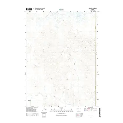
2014 Map of Hoagland
USGS Topo · Published 2014About this map
Hoagland sits at the southwestern edge of this landscape, positioned where the valley floor meets the intricate, undulating terrain of the Nebraska Sandhills. The S Loup River winds across the southern reaches of the map, providing a vital water source in an otherwise high, arid region defined by dense topographic contours. This 2014 survey reveals a sparse settlement pattern characteristic of the area, where human presence is largely limited to the river valley and a few persistent corridors like Halstead Ln. The map also delineates the jurisdictional boundary between Logan Co and Custer Co, illustrating how these historical county lines cut across the complex physical geography of the central plains.
Find a feature on this map
4 named features on this map. Tap any name to fly to it.
Don’t see what you’re looking for? This feature index may not catch every label — zoom into the map to look around manually.
Map Details
Editions of this 2014 Hoagland Map
This is the sole edition of this map. No revisions or reprints were ever made.
Other maps of this area

1948 · Linscott
USGS Topo · 1:62,500

1950 · Linscott
USGS Topo · 1:62,500

1951 · Hoagland
USGS Topo · 1:62,500

1954 · North Platte
USGS Topo · 1:250,000

1956 · North Platte
USGS Topo · 1:250,000

1957 · North Platte
USGS Topo · 1:250,000

1967 · North Platte
USGS Topo · 1:250,000

1972 · Logan
USGS Topo · 1:24,000

1972 · Arnold
USGS Topo · 1:24,000
1972 · Gandy
USGS Topo · 1:24,000