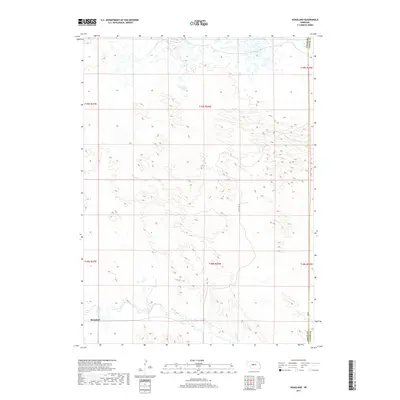
2017 Map of Hoagland
USGS Topo · Published 2017About this map
Hoagland sits along the southern edge of this landscape in the Sandhills of Nebraska, where the terrain is defined by a dense network of dunes and depressions. The most significant hydrologic feature is the S Loup River, which winds through the southwestern corner of the quadrangle. Most of the map area is characterized by these complex landforms, with very few established roads reaching into the interior sections. Along the eastern margin, the Logan Co Custer Co boundary line runs north-to-south, marking the divide between these two rural counties. Local transportation is limited to routes like Halstead Ln and 408 Rd, highlighting the remote nature of this ranching country in the early twenty-first century.
Find a feature on this map
5 named features on this map. Tap any name to fly to it.
Don’t see what you’re looking for? This feature index may not catch every label — zoom into the map to look around manually.
Map Details
Editions of this 2017 Hoagland Map
This is the sole edition of this map. No revisions or reprints were ever made.
Other maps of this area

1948 · Linscott
USGS Topo · 1:62,500

1950 · Linscott
USGS Topo · 1:62,500

1951 · Hoagland
USGS Topo · 1:62,500

1954 · North Platte
USGS Topo · 1:250,000

1956 · North Platte
USGS Topo · 1:250,000

1957 · North Platte
USGS Topo · 1:250,000

1967 · North Platte
USGS Topo · 1:250,000

1972 · Logan
USGS Topo · 1:24,000

1972 · Arnold
USGS Topo · 1:24,000
1972 · Gandy
USGS Topo · 1:24,000