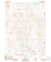
1986 Map of Hoagland
USGS Topo · Published 1987About this map
Hoagland and the surrounding ranching landscape define this portion of the Nebraska Sandhills in the mid-1980s. The settlement pattern is characterized by scattered operations like Collier Ranch, Halstead Ranch, and Wiley Ranch, illustrating the sparse, land-intensive nature of cattle country along the Logan Co Custer Co line. The South Fork Loup River winds through the southern portion of the quadrangle, serving as the primary drainage and a critical water source for the region's agricultural economy. This topographic survey captures the intricate contouring of the stabilized dunes, showing the isolated locations of Stewart Ranch and Shaw Ranch relative to the river valley. The map provides a detailed view of the rural road network and section lines that structured the settlement of this high plains environment during the late twentieth century.
Find a feature on this map
9 named features on this map. Tap any name to fly to it.
Don’t see what you’re looking for? This feature index may not catch every label — zoom into the map to look around manually.
Map Details
Editions of this 1986 Hoagland Map
This is the sole edition of this map. No revisions or reprints were ever made.
Other maps of this area

1948 · Linscott
USGS Topo · 1:62,500

1950 · Linscott
USGS Topo · 1:62,500

1951 · Hoagland
USGS Topo · 1:62,500

1954 · North Platte
USGS Topo · 1:250,000

1956 · North Platte
USGS Topo · 1:250,000

1957 · North Platte
USGS Topo · 1:250,000

1967 · North Platte
USGS Topo · 1:250,000

1972 · Logan
USGS Topo · 1:24,000

1972 · Arnold
USGS Topo · 1:24,000
1972 · Gandy
USGS Topo · 1:24,000