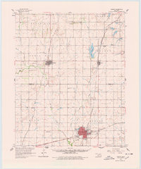
1961 Map of Hobart
USGS Topo · Published 1978About this map
Hobart serves as the regional anchor on this Kiowa County survey, where a complex network of steel rails defines the agricultural economy of the early 1960s. The Chicago Rock Island and Pacific and the St Louis San Francisco railroads intersect here, supporting local industry evidenced by the Gravel Pit and a large oil field to the southeast. To the north, the town of Sentinel sits near the headwaters of Trail Cr, surrounded by long-established rural landmarks like Huckleby Cem and Sentinel Cem.
Find a feature on this map
38 named features on this map. Tap any name to fly to it.
Don’t see what you’re looking for? This feature index may not catch every label — zoom into the map to look around manually.
Map Details
Editions of this 1961 Hobart Map
2 editions found
Other maps of this area

1949 · Cooperton
USGS Topo · 1:62,500

1955 · Lawton
USGS Topo · 1:250,000

1955 · Clinton
USGS Topo · 1:250,000

1956 · Cordell
USGS Topo · 1:62,500

1956 · Rainy Mountain Creek
USGS Topo · 1:24,000

1956 · Cooperton
USGS Topo · 1:62,500

1957 · Clinton
USGS Topo · 1:250,000

1957 · Dill City
USGS Topo · 1:62,500

1961 · Gotebo
USGS Topo · 1:62,500

1961 · Hobart
USGS Topo · 1:62,500