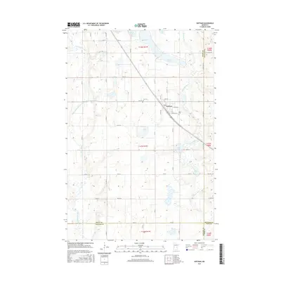
2016 Map of Hoffman
USGS Topo · Published 2016About this map
Hoffman serves as the central hub of this prairie and lake landscape, situated where the Chippewa River drainage meets a dense network of glacial basins. The settlement pattern here is defined by a rigid grid of township and county roads, such as Co Hwy 5 and Co Rd 38, which navigate around a prolific number of water bodies including Elk Lake, Wilson Lake, and Bolin Lake. This 2016 survey captures the area at a time when the rural character is anchored by established local sites like Land Cem, Zion Cem, and Bethel Cem. To the west, the Pomme de Terre River carves a distinct path through the terrain, contrasting with the more stationary waters of Spring Lake and Olson Lake to the north. The proximity of the Grant, Douglas, Stevens, and Pope county lines underscores the map's value for researchers tracing property and jurisdictional history in this multi-county corner of Minnesota.
Find a feature on this map
67 named features on this map. Tap any name to fly to it.
Don’t see what you’re looking for? This feature index may not catch every label — zoom into the map to look around manually.
Map Details
Editions of this 2016 Hoffman Map
This is the sole edition of this map. No revisions or reprints were ever made.
Other maps of this area

1911 · Barrett
USGS Topo · 1:62,500

1912 · Morris
USGS Topo · 1:62,500

1953 · Saint Cloud
USGS Topo · 1:250,000

1957 · Saint Cloud
USGS Topo · 1:250,000

1958 · Saint Cloud
USGS Topo · 1:250,000

1966 · Kensington
USGS Topo · 1:24,000

1966 · Quam Lake
USGS Topo · 1:24,000

1968 · Starbuck NW
USGS Topo · 1:24,000
1973 · Patchen Lake
USGS Topo · 1:24,000
1973 · Pomme De Terre Lakes
USGS Topo · 1:24,000