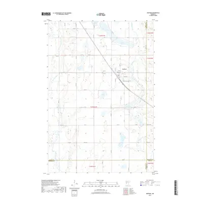
2019 Map of Hoffman
USGS Topo · Published 2019About this map
Hoffman serves as the central hub of this western Minnesota landscape, situated at the confluence of several county roads and local avenues. The topography is defined by its glacial hydrology, featuring a dense network of water bodies including Elk Lake, Lower Elk Lake, and the meandering Chippewa River which threads through the eastern sections. To the west, the Pomme de Terre River carves a separate path, illustrating the complex drainage patterns of Grant and Douglas counties. Local history and genealogy are anchored by several established burial grounds near the town center, including Zion Cem, Land Cem, and Bethel Cem. The map reveals a structured rural grid of township roads like TWP RD 176 and TWP RD 184 that support the agricultural parcels surrounding the residential core of Hoffman, where the Po marks the community center.
Find a feature on this map
54 named features on this map. Tap any name to fly to it.
Don’t see what you’re looking for? This feature index may not catch every label — zoom into the map to look around manually.
Map Details
Editions of this 2019 Hoffman Map
This is the sole edition of this map. No revisions or reprints were ever made.
Other maps of this area

1911 · Barrett
USGS Topo · 1:62,500

1912 · Morris
USGS Topo · 1:62,500

1953 · Saint Cloud
USGS Topo · 1:250,000

1957 · Saint Cloud
USGS Topo · 1:250,000

1958 · Saint Cloud
USGS Topo · 1:250,000

1966 · Kensington
USGS Topo · 1:24,000

1966 · Quam Lake
USGS Topo · 1:24,000

1968 · Starbuck NW
USGS Topo · 1:24,000
1973 · Patchen Lake
USGS Topo · 1:24,000
1973 · Pomme De Terre Lakes
USGS Topo · 1:24,000