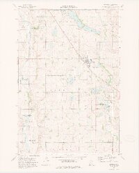
1973 Map of Hoffman
USGS Topo · Published 1975About this map
Hoffman serves as the central hub of this west-central Minnesota landscape, situated at the junction of the Soo Line and local transit routes. The town is flanked by a significant concentration of memorial sites, including Bethel Cem to the south and both Zion Cem and Land Cem to the northwest, providing valuable coordinates for genealogical research in Grant County. The terrain is defined by a dense network of glacial lakes and wetlands, most notably Elk Lake and Lower Elk Lake, which are protected within the expansive National Waterfowl Production Area. Drainage patterns are dictated by the Chippewa River flowing through the eastern reaches and the Pomme De Terre River to the west. This 1970s survey illustrates a rural economy balanced between agriculture and conservation, where numerous Gravel Pits dot the countryside alongside the Chippewa State Wildlife Management Area.
Find a feature on this map
30 named features on this map. Tap any name to fly to it.
Don’t see what you’re looking for? This feature index may not catch every label — zoom into the map to look around manually.
Map Details
Editions of this 1973 Hoffman Map
This is the sole edition of this map. No revisions or reprints were ever made.
Other maps of this area

1911 · Barrett
USGS Topo · 1:62,500

1912 · Morris
USGS Topo · 1:62,500

1953 · Saint Cloud
USGS Topo · 1:250,000

1957 · Saint Cloud
USGS Topo · 1:250,000

1958 · Saint Cloud
USGS Topo · 1:250,000

1966 · Kensington
USGS Topo · 1:24,000

1966 · Quam Lake
USGS Topo · 1:24,000

1968 · Starbuck NW
USGS Topo · 1:24,000
1973 · Patchen Lake
USGS Topo · 1:24,000
1973 · Pomme De Terre Lakes
USGS Topo · 1:24,000