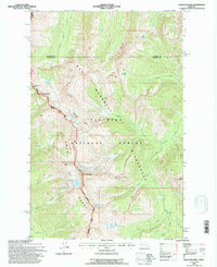
1994 Map of Holland Peak
USGS Topo · Published 1996About this map
The high alpine crest of the Swan Range serves as a natural divide within this section of the Flathead National Forest. Dominated by the soaring heights of Holland Peak and Cooney Mountain, the landscape transitions from the jagged ridgelines of the Bob Marshall Wilderness into deep glacial basins. The drainage network is particularly dense here, with Little Salmon Creek and Gordon Creek carving through the northern sections while Cataract Creek and South Fork feed the complex aquatic system to the south.
Find a feature on this map
30 named features on this map. Tap any name to fly to it.
Don’t see what you’re looking for? This feature index may not catch every label — zoom into the map to look around manually.
Map Details
Editions of this 1994 Holland Peak Map
This is the sole edition of this map. No revisions or reprints were ever made.
Other maps of this area

1902 · Ovando
USGS Topo · 1:125,000

1905 · Ovando
USGS Topo · 1:125,000

1921 · Elbow Lake
USGS Topo · 1:125,000

1936 · Silvertip
USGS Topo · 1:96,000

1942 · Silvertip
USGS Topo · 1:125,000

1955 · Choteau
USGS Topo · 1:250,000

1957 · Choteau
USGS Topo · 1:250,000

1958 · Choteau
USGS Topo · 1:250,000

1962 · Choteau
USGS Topo · 1:250,000

1965 · Condon
USGS Topo · 1:24,000