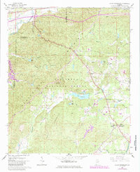
1967 Map of Hollis Crossroads
USGS Topo · Published 1985About this map
Talladega National Forest encompasses much of this Alabama landscape, where the ridges of Horseblock Mountain and the high point of Mountain dominate the horizon. In the late 1960s, these highlands remained sparsely populated, defined by forest trails like the Skyway Motorway and the historic Jackson Trace. Water resources are a central theme, from the southern Tallapossa River to secluded impoundments like Lake Edmond, Abel Lake, and the cluster of Gold Mine Lakes. Local life centered around small crossroads settlements and community hubs such as Hollis Crossroads and Chulafinnee. The map documents numerous landmarks essential for genealogical research, including the Bethlehem Cem and Mountain Grove Ch, while the Lookout Tower standing near Abel Gap provides a clear perspective on the era's fire-management infrastructure in the deep woods of the Piedmont region.
Find a feature on this map
39 named features on this map. Tap any name to fly to it.
Don’t see what you’re looking for? This feature index may not catch every label — zoom into the map to look around manually.
Map Details
Editions of this 1967 Hollis Crossroads Map
3 editions found
Other maps of this area

1891 · Ashland
USGS Topo · 1:125,000

1900 · Anniston
USGS Topo · 1:125,000

1947 · Oxford
USGS Topo · 1:24,000

1947 · Anniston
USGS Topo · 1:24,000

1950 · Anniston
USGS Topo · 1:62,500

1953 · Atlanta
USGS Topo · 1:250,000

1954 · Choccolocco
USGS Topo · 1:24,000

1956 · Oxford
USGS Topo · 1:24,000

1956 · Anniston
USGS Topo · 1:24,000

1957 · Atlanta
USGS Topo · 1:250,000