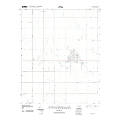
2010 Map of Hollis
USGS Topo · Published 2010About this map
Hollis serves as the primary urban center for this Oklahoma landscape, defined by a grid of agricultural section roads and the meandering paths of Bitter Creek and the West Fork Sandy Creek. The town's grid is dense with residential streets, anchored by Edwards St and surrounded by aviation facilities like Hollis Municipal Airport and Ray Preston Airport. North of the main settlement, the smaller locality of Arnett sits near the northern boundary. Genealogists will find significant value in the distribution of burial grounds across the quadrangle, including Bitter Creek Cemetery in the northwest, Number 2 Cemetery to the west of town, and Fairmount Cemetery situated near the southern edge of the municipal area. The drainage patterns of the East Fork Sandy Creek further illustrate the region's hydrology, cutting through the geometric regularity of the section-line roads.
Find a feature on this map
26 named features on this map. Tap any name to fly to it.
Don’t see what you’re looking for? This feature index may not catch every label — zoom into the map to look around manually.
Map Details
Editions of this 2010 Hollis Map
This is the sole edition of this map. No revisions or reprints were ever made.
Other maps of this area

1954 · Plainview
USGS Topo · 1:250,000

1955 · Lawton
USGS Topo · 1:250,000

1958 · Plainview
USGS Topo · 1:250,000

1960 · Loco
USGS Topo · 1:62,500

1961 · Hollis
USGS Topo · 1:62,500

1964 · Dodson
USGS Topo · 1:24,000
1971 · Mc Knight
USGS Topo · 1:24,000
1971 · Shrewder
USGS Topo · 1:24,000

1975 · Hollis NE
USGS Topo · 1:24,000

1975 · Hollis SE
USGS Topo · 1:24,000