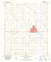
1985 Map of Hollis
USGS Topo · Published 1985About this map
Hollis serves as the central hub of this Harmon County landscape, where the local economy is anchored by the Municipal Airport, a Drive-in Theater, and the regional Hosp. The surrounding agricultural territory is defined by the drainage of Bitter Creek and the various branches of Sandy Creek, including East Fork Sandy Creek and West Fork Sandy Creek. Evidence of earlier transportation networks is visible in the Old Railroad Grade that cuts diagonally through the western sections toward Arnett. For those researching local history, the map preserves the locations of vital community institutions such as Antioch Ch, Bitter Creek Cemetery, and No 2 Cemetery, alongside Fairmount Cemetery south of the main town. The concentrated layout of Hollis, featuring the High Sch and Abernathy Park, contrasts with the dispersed wells and storage bins that characterize the productive rural sections of the southern Great Plains.
Find a feature on this map
24 named features on this map. Tap any name to fly to it.
Don’t see what you’re looking for? This feature index may not catch every label — zoom into the map to look around manually.
Map Details
Editions of this 1985 Hollis Map
This is the sole edition of this map. No revisions or reprints were ever made.
Other maps of this area

1954 · Plainview
USGS Topo · 1:250,000

1955 · Lawton
USGS Topo · 1:250,000

1958 · Plainview
USGS Topo · 1:250,000

1960 · Loco
USGS Topo · 1:62,500

1961 · Hollis
USGS Topo · 1:62,500

1964 · Dodson
USGS Topo · 1:24,000
1971 · Mc Knight
USGS Topo · 1:24,000
1971 · Shrewder
USGS Topo · 1:24,000

1975 · Hollis NE
USGS Topo · 1:24,000

1975 · Hollis SE
USGS Topo · 1:24,000