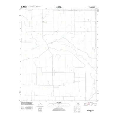
2010 Map of Hollis SW
USGS Topo · Published 2010About this map
The Prairie Dog Town Fork Red River meanders across this rural borderland between Oklahoma and Texas, defining a landscape shaped by hydrology and agriculture. In the northern reaches of the quadrangle, the Halsmith Cemetery serves as a quiet landmark for local genealogical research, situated among a rectilinear grid of section roads like E 1660 Rd and N 1680 Rd. Further south, the terrain is cut by the seasonal flows of Buck Creek and Tepee Creek, which feed into the broader Red River system. The area is interlaced with named local thoroughfares, including Trolinder Rd, Watson Rd, and Hollis Rd, reflecting a dispersed ranching and farming community that remains centered on the river's historical drainage patterns.
Find a feature on this map
23 named features on this map. Tap any name to fly to it.
Don’t see what you’re looking for? This feature index may not catch every label — zoom into the map to look around manually.
Map Details
Editions of this 2010 Hollis SW Map
This is the sole edition of this map. No revisions or reprints were ever made.
Other maps of this area

1954 · Plainview
USGS Topo · 1:250,000

1955 · Lawton
USGS Topo · 1:250,000

1958 · Plainview
USGS Topo · 1:250,000

1960 · Goodlett
USGS Topo · 1:62,500

1960 · Loco
USGS Topo · 1:62,500

1961 · Hollis
USGS Topo · 1:62,500

1967 · Kirkland North
USGS Topo · 1:24,000

1975 · Hollis NE
USGS Topo · 1:24,000

1975 · Hollis SE
USGS Topo · 1:24,000
1975 · Hollis NW
USGS Topo · 1:24,000