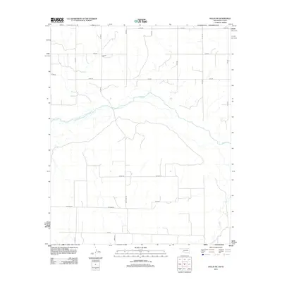
2012 Map of Hollis SW
USGS Topo · Published 2012About this map
Halsmith Cem sits on the northern plains of this borderland region, marking a quiet point of local genealogy in a landscape defined by the winding course of the Prairie Dog Town Fork Red River. This 2012 survey captures the expansive rural character of the Texas-Oklahoma border, where the primary Red River divides the terrain and receives the waters of Buck Cr from the northwest. The map documents a strictly organized grid of rural roads, including Trolinder Rd and Ranch Road 680, which serve the agricultural parcels across the territory. To the southeast, the drainage of Tepee Cr cuts through the lower elevations, highlighting the intricate natural hydrology that persists alongside the modern ranching and farming infrastructure of Childress County.
Find a feature on this map
24 named features on this map. Tap any name to fly to it.
Don’t see what you’re looking for? This feature index may not catch every label — zoom into the map to look around manually.
Map Details
Editions of this 2012 Hollis SW Map
This is the sole edition of this map. No revisions or reprints were ever made.
Other maps of this area

1954 · Plainview
USGS Topo · 1:250,000

1955 · Lawton
USGS Topo · 1:250,000

1958 · Plainview
USGS Topo · 1:250,000

1960 · Goodlett
USGS Topo · 1:62,500

1960 · Loco
USGS Topo · 1:62,500

1961 · Hollis
USGS Topo · 1:62,500

1967 · Kirkland North
USGS Topo · 1:24,000

1975 · Hollis NE
USGS Topo · 1:24,000

1975 · Hollis SE
USGS Topo · 1:24,000
1975 · Hollis NW
USGS Topo · 1:24,000