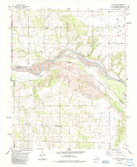
1985 Map of Hollis SW
USGS Topo · Published 1985About this map
The Red River and the Prairie Dog Town Fork Red River converge in this borderlands region of Harmon County, Oklahoma, and Childress County, Texas. This mid-1980s survey illustrates a landscape defined by water management and rural landmarks, notably the Hooleyan Church and Halsmith Cemetery located north of the river system. The terrain transitions into Star Valley in the northeast, while the interior is punctuated by numerous wells and a network of pipelines. Traces of early regional infrastructure are visible through several tributaries, including Buck Creek and Teepee Creek, which feed into the primary river fork. The presence of a Radio Tower and a Water Tank marks the higher ground, providing clear points of orientation within this agricultural and energy-producing territory.
Find a feature on this map
19 named features on this map. Tap any name to fly to it.
Don’t see what you’re looking for? This feature index may not catch every label — zoom into the map to look around manually.
Map Details
Editions of this 1985 Hollis SW Map
This is the sole edition of this map. No revisions or reprints were ever made.
Other maps of this area

1954 · Plainview
USGS Topo · 1:250,000

1955 · Lawton
USGS Topo · 1:250,000

1958 · Plainview
USGS Topo · 1:250,000

1960 · Goodlett
USGS Topo · 1:62,500

1960 · Loco
USGS Topo · 1:62,500

1961 · Hollis
USGS Topo · 1:62,500

1967 · Kirkland North
USGS Topo · 1:24,000

1975 · Hollis NE
USGS Topo · 1:24,000

1975 · Hollis SE
USGS Topo · 1:24,000
1975 · Hollis NW
USGS Topo · 1:24,000