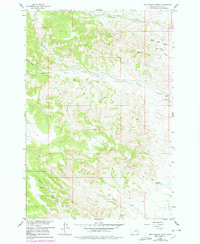
1958 Map of Hollowwood Creek
USGS Topo · Published 1978About this map
Hollowwood Creek defines the central drainage of this landscape within the Northern Cheyenne Indian Reservation, where a series of named creeks and coulees carve through the Rosebud County terrain. The survey, field-checked in the late 1950s with updates through the 1970s, captures a rural area shaped by its water sources and livestock-rearing potential, featuring numerous Springs and the Bighead Reservoir to the south. Distinctive local names like Woodenthigh Creek, Crazy Head Fork, and Walking Horse Coulee reflect the area's cultural history and geographic character. While predominantly undeveloped, the map reveals specific human imprints on the land, including a Landing Strip near Logging Creek and a network of Jeep Trails that provide access to remote points like the Rattler summit and various wells scattered across the hills.
Find a feature on this map
19 named features on this map. Tap any name to fly to it.
Don’t see what you’re looking for? This feature index may not catch every label — zoom into the map to look around manually.
Map Details
Editions of this 1958 Hollowwood Creek Map
3 editions found
Other maps of this area

1954 · Hardin
USGS Topo · 1:250,000

1957 · Hardin
USGS Topo · 1:250,000

1958 · Hardin
USGS Topo · 1:250,000

1958 · Garfield Peak
USGS Topo · 1:24,000

1958 · Fisher Butte
USGS Topo · 1:24,000

1958 · Badger Peak
USGS Topo · 1:24,000

1958 · Hollowwood Creek
USGS Topo · 1:24,000

1966 · Ashland
USGS Topo · 1:24,000

1966 · Birney Day School
USGS Topo · 1:24,000

1966 · Ashland NE
USGS Topo · 1:24,000