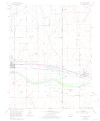
1953 Map of Holly East
USGS Topo · Published 1978About this map
Arkansas River valley life in the mid-1950s is defined by the complex irrigation networks of the Buffalo Canal and the now-defunct Amity Canal (Aband). This borderland where Colorado meets Kansas preserves significant historical transit corridors, most notably the Old Santa Fe Trail (Approximate), marked here by a specific Santa Fe Trail Marker near the Site of Old Trail City. The twin settlements of Holly and Coolidge anchor the landscape, connected by the vital Atchison Topeka and Santa Fe railroad line. The map reveals a transition from river-bottom agriculture to the dry highlands drained by East Horse Creek and Spring Creek, punctuated by local infrastructure like the Holly Landing Strip and small industrial sites such as a Sand Pit and Gravel Pit.
Find a feature on this map
22 named features on this map. Tap any name to fly to it.
Don’t see what you’re looking for? This feature index may not catch every label — zoom into the map to look around manually.
Map Details
Editions of this 1953 Holly East Map
4 editions found
Other maps of this area

1890 · Granada
USGS Topo · 1:125,000

1891 · Albany
USGS Topo · 1:125,000

1892 · Granada
USGS Topo · 1:125,000

1893 · Albany
USGS Topo · 1:125,000

1894 · Granada
USGS Topo · 1:125,000

1900 · Syracuse
USGS Topo · 1:125,000

1920 · Syracuse
USGS Topo · 1:125,000

1953 · Holly West
USGS Topo · 1:24,000

1953 · Holly East
USGS Topo · 1:24,000

1954 · Lamar
USGS Topo · 1:250,000