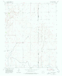
1955 Map of Holly NE
USGS Topo · Published 1977About this map
The Colorado and Kansas state line bisects this 1955 survey, where the semi-arid plains of Prowers and Hamilton counties meet. The landscape is defined by its water management infrastructure, most notably the Amity Canal and its later segments labeled as Amity Canal (Abandoned). These irrigation routes, along with a prominent Levee, trace the edge of the high plains where Wild Horse Creek and East Horse Creek converge. Evidence of early rural education and settlement is preserved in the location of a School (Aband) and the Richland area. The presence of a Gravel Pit and numerous unnamed wells indicates the era's local extractive and agricultural activity. Tributaries like Cheyenne Creek and Spring Creek add detail to the drainage patterns that shaped the regional topography during the mid-twentieth century.
Find a feature on this map
12 named features on this map. Tap any name to fly to it.
Don’t see what you’re looking for? This feature index may not catch every label — zoom into the map to look around manually.
Map Details
Editions of this 1955 Holly NE Map
3 editions found
Other maps of this area

1890 · Granada
USGS Topo · 1:125,000

1892 · Granada
USGS Topo · 1:125,000

1894 · Granada
USGS Topo · 1:125,000

1953 · Holly West
USGS Topo · 1:24,000

1953 · Holly East
USGS Topo · 1:24,000

1954 · Lamar
USGS Topo · 1:250,000

1955 · Holly NE
USGS Topo · 1:24,000
1955 · Holly NW
USGS Topo · 1:24,000

1955 · Scott City
USGS Topo · 1:250,000

1958 · Lamar
USGS Topo · 1:250,000