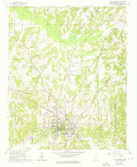
1965 Map of Holly Springs
USGS Topo · Published 1976About this map
Holly Springs serves as a significant educational and transportation hub in this mid-1960s study, featuring a dense concentration of institutions including Rust College, Mississippi Industrial College, and Bishop Cottrell Coll. The town is the meeting point for the Illinois Central and St Louis-San Francisco railroads, reflecting its historical role as a regional trade center. Outside the municipal grid, the landscape transitions into the Holly Springs National Forest to the southeast, while the Coldwater River and Dawson Creek drain the northern reaches of the quadrangle. Local genealogy is well-documented through numerous family-named landmarks and cemeteries such as McAlexander Cem, Seals Cem, and Strawberry Plains Ch. Industrial activity is represented by several claypits west of town, indicating the importance of local mineral resources to the area's economy.
Find a feature on this map
41 named features on this map. Tap any name to fly to it.
Don’t see what you’re looking for? This feature index may not catch every label — zoom into the map to look around manually.
Map Details
Editions of this 1965 Holly Springs Map
2 editions found
Other maps of this area

1944 · Tyro
USGS Topo · 1:62,500

1944 · Potts Camp
USGS Topo · 1:62,500

1945 · Potts Camp
USGS Topo · 1:62,500

1948 · Byhalia
USGS Topo · 1:62,500

1953 · Holly Springs
USGS Topo · 1:62,500

1956 · Tupelo
USGS Topo · 1:250,000

1958 · Tupelo
USGS Topo · 1:250,000

1964 · Waterford
USGS Topo · 1:24,000

1964 · Holly Springs SE
USGS Topo · 1:24,000
1965 · Slayden
USGS Topo · 1:24,000