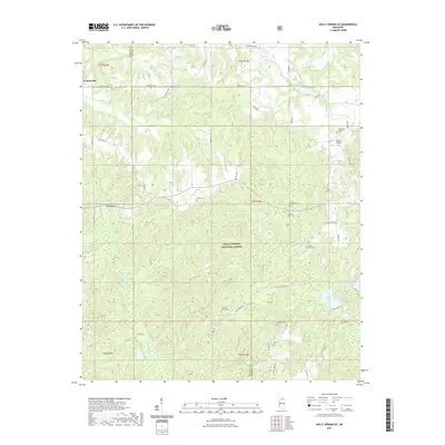
2021 Map of Holly Springs SE
USGS Topo · Published 2021About this map
Hudsonville stands as a focal point in this portion of the North Mississippi hill country, where the landscape is defined by the headwaters and tributaries of the Coldwater River. Much of the southern half of the region is occupied by the Holly Springs National Forest, a terrain characterized by dense drainages such as Snow Creek and Chewalla Creek. This 2021 survey reveals a rural network of family and community landmarks, particularly evident in the distribution of local burial grounds. Genealogists and historians will find interest in several documented sites, including the Governor Matthews Cem near the eastern boundary and the Mount Zion Cem further south. The area’s aviation history is noted by the presence of Nichol Airpark, while recreational and hydrological features like Snow Lake and Little Snow Lake mark the transition between forest and private holdings near the border of Marshall and Benton counties.
Find a feature on this map
51 named features on this map. Tap any name to fly to it.
Don’t see what you’re looking for? This feature index may not catch every label — zoom into the map to look around manually.
Map Details
Editions of this 2021 Holly Springs SE Map
This is the sole edition of this map. No revisions or reprints were ever made.
Other maps of this area

1944 · Potts Camp
USGS Topo · 1:62,500

1945 · Potts Camp
USGS Topo · 1:62,500

1950 · Ashland
USGS Topo · 1:62,500

1953 · Holly Springs
USGS Topo · 1:62,500

1955 · Blue Mountain
USGS Topo · 1:62,500

1956 · Tupelo
USGS Topo · 1:250,000

1958 · Tupelo
USGS Topo · 1:250,000

1964 · Waterford
USGS Topo · 1:24,000

1964 · Holly Springs SE
USGS Topo · 1:24,000
1965 · Slayden
USGS Topo · 1:24,000