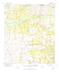
1956 Map of Holt
USGS Topo · Published 1965About this map
The Yellow River and its major tributaries, the Shoal River and Titi Creek, dominate this mid-century view of Okaloosa County. The landscape reflects a transition from river-and-rail commerce to a massive military footprint, as the Louisville and Nashville Railroad and the historic Old Spanish Trail run parallel through Holt, Galliver, and Milligan. To the south, the expansion of Eglin Air Force Base is evident, encompassing training grounds like Duke Field, Biancur Field, and Piccolo Field. Smaller rural details remain preserved on this sheet, including the Chatoola Lookout Tower and remote river access points such as Gin Hole Landing and Carr Landing. The northern reaches are characterized by the Blackwater River State Forest, while the southern border shows the burgeoning municipalities of Niceville and Valparaiso near Toms Bayou.
Find a feature on this map
69 named features on this map. Tap any name to fly to it.
Don’t see what you’re looking for? This feature index may not catch every label — zoom into the map to look around manually.
Map Details
Editions of this 1956 Holt Map
2 editions found

Other maps of this area

1921 · Holley
USGS Topo · 1:62,500

1934 · Holt
USGS Topo · 1:48,000

1934 · Harold
USGS Topo · 1:62,500

1934 · Niceville
USGS Topo · 1:48,000

1935 · Villa Tasso
USGS Topo · 1:48,000

1936 · Niceville
USGS Topo · 1:62,500

1936 · Holley
USGS Topo · 1:48,000

1937 · Holt
USGS Topo · 1:62,500

1937 · Harold
USGS Topo · 1:62,500

1938 · Mary Esther
USGS Topo · 1:62,500