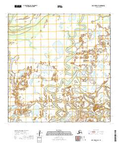
2019 Map of Holy Cross A-2 SE
USGS Topo · Published 2019About this map
Innoko Slough and Paimiut Slough dominate this low-lying riverine landscape in the Yukon-Koyukuk Census Area. The intricate network of waterways reflects the dynamic hydrology of the Alaskan interior, where seasonal shifts constantly reshape the drainage patterns of the floodplains. This 2019 survey documents the complex meandering of these sloughs as they cut through the wilderness of the t24n r57w and t23n r56w townships. For researchers of Alaskan geography, the map provides a precise record of watercourses in a region defined by its shifting aquatic boundaries rather than permanent human settlements.
Find a feature on this map
8 named features on this map. Tap any name to fly to it.
Don’t see what you’re looking for? This feature index may not catch every label — zoom into the map to look around manually.
Map Details
Editions of this 2019 Holy Cross A-2 SE Map
This is the sole edition of this map. No revisions or reprints were ever made.
Other maps of this area

1947 · Russian Mission
USGS Topo · 1:250,000

1950 · Russian Mission
USGS Topo · 1:250,000

1951 · Holy Cross
USGS Topo · 1:250,000

1952 · Holy Cross A-2
USGS Topo · 1:63,360

1952 · Holy Cross A-1
USGS Topo · 1:63,360

1952 · Russian Mission D-2
USGS Topo · 1:63,360

1952 · Holy Cross
USGS Topo · 1:250,000

1952 · Russian Mission D-3
USGS Topo · 1:63,360

1980 · Russian Mission
USGS Topo · 1:250,000
2019 · Russian Mission D-3 NE
USGS Topo · 1:25,000